Cool 2010 and 2011, but planet "still warming" says BoM


Still warming, just you wait…

If there were no agenda of global warming, there would be no need for comments like those of David Jones, reported in The Australian today.

The fact that a senior Bureau meteorologist believes it necessary to defend model projections that the planet will continue to warm, despite two cooler years (and a relatively flat global temperature profile for the last decade), reveals the motivations at work behind the scenes.

Environment editor at The Australian, Graham Lloyd, doesn’t help to dispel this impression, and warns “those looking to disprove climate change” that the planet is still warming [er, who’s trying to “disprove climate change” again?].

“In 2011, the La Nina and heavy rainfall acted like an evaporative cooler for Australia,” said bureau climate change spokesman David Jones.

“The year 2010 was relatively cool in recent historical context and 2011 was cooler again.”

Mr Jones said there was no evidence to link the strong La Nina weather systems with changing global temperatures.

“We have had this regular cycle of La Nina and El Nino,” he said. “The strongest El Nino on record was in 1997 and we have seen one of the strongest La Ninas on record in 2010-11.”

Mr Jones said the climate science was not very clear on what would happen with El Nino and La Nina patterns, particularly at this early stage of global warming.

“We have only seen one degree of warming so far but we will see substantially more as we move through the century, but it is probably too early to draw any concrete relationship between hotter temperatures and La Nina,” he said.

“One simple thing we can say is we know La Nina are historically cooler for Australia but there is a big difference between variability and climate change.”

The BOM climate statement said Australia’s mean rainfall total for last year was 699mm, which was 234mm above the long-term average of 465mm, making it the third-wettest year since comparable records began in 1900.

Where’s Tim Flannery when you need him to explain all his failed predictions of a never-ending drought?

The Australian area averaged mean temperature was 0.14C below the 1961-1990 average of 21.81C. Last year, maximum temperatures averaged 0.25C below normal across the country, while minimum temperatures averaged 0.03C below normal.

And then Jones goes into full prickly defensive mode:

“Despite the slightly cooler conditions, the country’s 10-year average continues to demonstrate the rising trend in temperatures, with 2002-2011 likely to rank in the top two warmest 10-year periods on record for Australia, at 0.52C above the long-term average,” the bureau said.

“If you are interested in determining whether the planet is warming, you look at the global temperature,” Mr Jones said. (source)

And if you look at global temperatures for the last decade, there isn’t much warming to see there either.

If the BoM hadn’t sold out to climate alarmism, there wouldn’t be any need for such awkward justifications.

Sydney: coldest December in 50 years – no mention of "climate change"


December in Sydney

Naturally there shouldn’t be any mention of climate change in such an article – this is merely weather, after all.

Except of course, if it had been the “hottest” December in 50 years, we would have had all the usual rent-seekers and alarmists crawling out from under their rocks to announce that such a record was “entirely consistent with anthropogenic global warming” and that we can “expect more of the same in the future”… such are the blatant double standards endemic in both the alarmist camp and the mainstream media.

Actually, since you can now attribute anything and everything to climate change, I wouldn’t be at all surprised to read some desperate hack on the ABC or the Silly Moaning Herald claiming that “greater extremes” such as a cold December, are “consistent” with some flaky climate model somewhere.

From the Daily Telegraph:

IT’S a good thing December is almost over – it’s been the coldest for more than 50 years.

With two days to go, it seems certain Sydney will record its coldest December since 1960, with the average daily maximum so far this month 2.2C below the long-term average.

Sydney’s average top temperature so far this month was a chilly 23C – only 0.2C more than in 1960.

That isn’t going to change much over the next two days, with the Bureau of Meteorology forecasting showers and tops of just 24C.

Not once has the temperature reached 30C in the city this month, the first time since 1999 the mercury has failed to reach that mark in December.

Even in 1960, Sydney recorded two days with top temperatures above 30C.

The Weather Channel meteorologist Dick Whitaker said Sydney wasn’t the only city to suffer a cold start to summer, with Canberra and Brisbane also experiencing below average temperatures.

“Across eastern Australia we had a lot of cloud cover in December and on top of that we had an above average frequency of southerly winds,” Mr Whitaker said. (source)

In other news, the Daily Bayonet has crowned Julia Gillard as Hippie of the Year. She deserves nothing less.

Happy New Year!

Brisbane: coldest December day in 123 years


Throw another reindeer on the barbie…

Another from the Weather Isn’t Climate Department:

Cloud and rain has limited Brisbane’s temperature to 19.1 degrees so far today, putting the city on track for its coldest December day since 1888.

20mm of rain had drenched the city between 9am and 3pm, while the associated cloud cover had blocked out the warming rays of the summer sun.

The highest temperature recorded after 9am in Brisbane was 19.1 degrees, which is around 10 below average for the month of December. The main Brisbane weather site only has 12 years of continuous records, but checking surrounding sites from the city and the old regional office site, the current maximum of 19.1 would be the lowest recorded since 1888 (assuming we stay at or below 19.3 until 9am on Thursday). (source)

Of course, this story is as meaningless in relation to climate as all those hysterical claims that hot days are a sign of “global warming”.

Sydney: coolest start to Summer in 51 years


Sydney storms

From the Weather Isn’t Climate Department:

Thunderstorms are helping Sydney achieve its coolest start to summer in 51 years, according to weatherzone.com.au.

Thunderstorms rolled across the city late this morning and early afternoon, cooling most suburbs below 17 degrees, well below average for this time of year. The storms also brought brief rain and hail to some western and northern suburbs. Picnickers and beach-goers were sent scurrying.

“In the first four days of this summer, Sydney has now failed to reach 23 degrees, making it the coolest start in 44 years,” Weatherzone meteorologist Brett Dutschke said.

“The city is on target for its coolest start to summer in 51 years with none of the next three days expected to reach 23 degrees,” Dutschke said.

In the summer of 1960, each of the first 10 days were cooler than 22 degrees. (source)

Bring me sunshine…

Early snow in US: global warming blamed in 3, 2, 1…


Flakes of global warming

From the Weather Isn’t Climate Department. As we all know, every weather phenomenon can be blamed on global warming – it’s an unfalsifiable hypothesis, the gift that keeps on giving! If it’s unseasonably hot: global warming. More rainfall: global warming. Drought: global warming. Less snow: global warming. More snow: global warming.

So it’s only a matter of time before some climate “scientist” breaks cover and says that this early snowfall in the US is “entirely consistent” with climate change projections. Because everything is “entirely consistent” with some climate model somewhere. Ask a climate scientist if any particular weather phenomenon could possibly disprove the theory of AGW and there will be a long, stony silence.

An unseasonable snowstorm has hit the US East Coast, threatening to bring up to 10in (25cm) of early snowfall.

The National Weather Service (NWS) has issued a winter storm warning from Saturday into Sunday and says travel conditions may be hazardous.

Heavy snow has begun falling across parts of Pennsylvania. About 10,000 people there, as well as in Maryland and West Virginia, are without power.

In 1979, southern New England received a record 7.5in of snow in October.

A region of low pressure brewing off the mid-Atlantic coast is expected to produce heavy, wet snow as it moves north-east, the NWS said.

The Massachusetts Berkshires, north-western Connecticut and southern New Hampshire could see the most snow.

Big coastal cities are set to be hit, forecasters say, with New York expecting 4in (10cm) on Saturday, and Boston 3in. 

Winds along the coast could reach 45mph (72km/h), further damaging power lines, the NWS said. (BBC)

Early snow in Switzerland. Alarmists blame "global warming" in 3, 2, 1…


Six inches of global warming…

I didn’t know Al Gore was in Switzerland at the moment… From the Weather Isn’t Climate Department. 

RECORD SNOWFALL IN SWITZERLAND – 45CM IN ST MORITZ

Snow fell in the Swiss Alps overnight Sunday to levels unseen for the month of September, Swiss weather agency Meteosuisse reported on Monday.

In the ski resort of St Moritz, in the southeast canton of Grison, a total of 45 centimetres (nearly 18 inches) of snow was recorded on Monday morning, it said.

The weather agency said the high levels of precipitation were due to a cold front which lowered the snow line to 800 metres (2,600 feet).

Rainfall was also higher than usual, with around 100 liters per square meter measured in the town of Santa Maria, also in Grison, the highest level since records began in 1901, Meteosuisse said.

The snowfall also provoked traffic disturbances in the mountains, with the St Bernard, Flueela and Nufenen passes closed, according to ViaSuisse, which reports on the condition of Swiss roads.

The Gothard, Lukmanier and Oberalp passes are also covered in snow, it added. (source)

Dang, that global warming sure is tricky ain’t it?

UK: coldest summer since 1993


Not exactly Bondi, is it?

From the Weather Isn’t Climate Department. Ah, memories of an English summer’s day on the beach when I was a kid – before Global Warming, that is: covered in goosebumps, sand in the ice-cream, the bucket and spade are halfway to France, with the beach-ball not far behind, desperately trying to stop Granny’s deck chair from taking off, and now it’s drizzling. Idyllic. Looks like those halcyon days might be on the way back:

As Britons return to work today after a soggy Bank Holiday weekend, official weather data reveals that average temperatures were significantly down on recent years.

The UK’s average temperature from June 1 to August 15 was only 57F (13.9C) – the lowest for 13 years.

For central England the average was 59F (15C), making it the coolest summer since 1993.

Helen Waite, a Met Office forecaster, said: “The average temperature for central England this summer has been just 15C – this sort of temperature is normally typical of September.

“Generally speaking, you would expect to see temperatures of at least 17C for this time of year.”

Source.

Australia's coldest Autumn "since at least 1950"


Autumn 2011 mean anomaly

From the Bureau of Meteorology (Weather Isn’t Climate Except When We Say It Is Department):

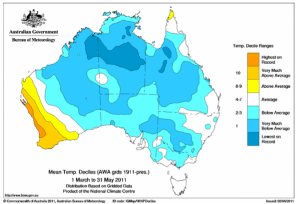
Australia has experienced its coldest autumn since at least 1950 for mean temperatures (average of maximum and minimum temperatures across the nation) with an Australian average of 20.9oC. This was 1.15oC below the historical average, and 0.2oC below the previous coolest autumn in 1960. It was also the coldest autumn since at least 1950 for Queensland and the Northern Territory.

Large parts of the country recorded temperatures more than 2oC below the autumn average (figure 1) with about half the country ranking in the coldest 10% of years (figure 2 – pictured right). The season was marked by consistent below-normal temperatures in most areas, with only a few individual areas recording their coldest autumn on record. These areas were in northern and central Australia including the east Kimberley, the central Northern Territory and small parts of northern Queensland.

The cool conditions experienced in autumn 2011 are largely a result of the strong 2010/11 La Niña event which brought heavy rainfall and cool daytime temperatures to Australia, before decaying in late autumn. Of particular significance was March 2011 – Australia’s coldest and wettest March on record for maximum temperatures and third wettest month on record (for any calendar month).

Read it here (PDF).

(h/t Hockey Schtick)

Coldest July day in Sydney for 8 years


Chilly

From the High Temperatures Are Global Warming But Low Temperatures Are Just Weather department:

A sunny 19 degrees one day, a gloomy 12 the next – only once in the last 15 years has a Sydney day so warm been followed by one so cold, according to weatherzone.com.au.

If it doesn’t warm anymore between now and the morning, this has been a rare pair of days. By 4pm today it had only reached 12.1 degrees, after getting to 18.9 yesterday.

“Only once in the last 15 years has a colder day followed one so warm. That was in August 2008, when an 11.9-degree day followed a 20-degree one. In more than 150 years of records there have only been 11 occurrences in total, so you could call this a once-in-15-year event,” Weatherzone meteorologist Brett Dutschke said.

Sydney did have an equally cold day in July last year, so along with that day, this is the coldest July day in eight years. 

The city’s maximum temperature of 12.1 degrees is four below the average maximum for this time of year. For some western suburbs, it was even colder, only reaching nine in Richmond and 10 in Penrith, both eight below average and their coldest day in at least 15 years. (source)

Brass monkeys as they say.

NSW experiences "coldest winter in 12 years"


Brass monkeys

From the Weather Isn’t Climate Department. There are thousands of blog posts elsewhere in which you can read about the review of the IPCC that came out today [summary: it needs fundamental reform – surprise, surprise], so here’s a local story from New South Wales, Australia:

NSW shivered through its coldest winter in 12 years, while daytime temperatures in August hit their lowest since 1990.

NSW experienced average daytime temperatures of 15.9C, making it the coldest winter since 1998 and the 16th nippiest winter on record.

Climatologist at the Bureau of Meteorology (BoM), Shannon Symons says widespread rainfall also resulted in the wettest winter since 2005. [Which is odd, because the BoM are always predicting that global warming, er, climate change will cause massive droughts…]

“Northern inland regions received above, to very much above average rainfall and that was mainly in July and August, and that’s pretty much the case (across) NSW as well,” Ms Symons told AAP today.

Inland rainfall was attributed to a La Nina event, which creates cooler than average sea surface temperatures in the equatorial Pacific Ocean.

“When we have La Nina events we, not always, but usually see enhanced rainfall across eastern Australia,” Ms Symons said.

Then we have the inevitable caveat:

Ms Symons said in the coming months, temperatures should rise as NSW settles into spring. [Well, of course they will. Duh…]

She said the La Nina event should dissipate by summer, but while it continues, there are chances of above average rainfall in inland NSW and warmer nights. (source)

In other words, it’s only a temporary cooling, and global warming will really take off again very soon, just you wait and see. But hang on, Watts Up With That is reporting that La Niña is actually deepening still further. Spoils the story a bit.

(h/t Climate Realists)